


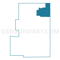
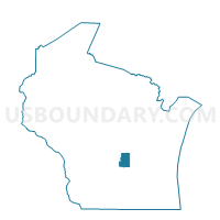
BERLIN - T 1 Voting District, Green Lake County, Wisconsin
About
Outline

Summary
| Unique Area Identifier | 694037 |
| Name | BERLIN - T 1 Voting District |
| County | Green Lake County |
| State | Wisconsin |
| Area (square miles) | 26.24 |
| Land Area (square miles) | 26.01 |
| Water Area (square miles) | 0.23 |
| % of Land Area | 99.12 |
| % of Water Area | 0.88 |
| Latitude of the Internal Point | 43.92854460 |
| Longtitude of the Internal Point | -88.93563620 |
Maps

Graphs
Select a template below for downloading or customizing gragh for BERLIN - T 1 Voting District, Green Lake County, Wisconsin


Neighbors
Neighoring Voting District (by Name) Neighboring Voting District on the Map
- AURORA - T 1 Voting District, Waushara County, WI
- Berlin - C 1 Voting District, Green Lake County, WI
- Berlin - C 2 Voting District, Green Lake County, WI
- Berlin - C 3 Voting District, Green Lake County, WI
- Berlin - C 4 Voting District, Green Lake County, WI
- Berlin - C 7 Voting District, Waushara County, WI
- Berlin - C 8 Voting District, Green Lake County, WI
- BERLIN - T 2 Voting District, Green Lake County, WI
- BROOKLYN - T 2 Voting District, Green Lake County, WI
- BROOKLYN - T 3 Voting District, Green Lake County, WI
- NEPEUSKUN - T 1 Voting District, Winnebago County, WI
- RIPON - T 1 Voting District, Fond du Lac County, WI
- RUSHFORD - T 1 Voting District, Winnebago County, WI
- ST MARIE - T 1 Voting District, Green Lake County, WI
Top 10 Neighboring County Subdivision (by Population) Neighboring County Subdivision on the Map
- Berlin city, Green Lake County, WI (5,435)
- Brooklyn town, Green Lake County, WI (1,826)
- Rushford town, Winnebago County, WI (1,561)
- Ripon town, Fond du Lac County, WI (1,400)
- Berlin town, Green Lake County, WI (1,140)
- Aurora town, Waushara County, WI (985)
- Nepeuskun town, Winnebago County, WI (710)
- St. Marie town, Green Lake County, WI (351)
- Berlin city, Waushara County, WI (89)
Top 10 Neighboring Place (by Population) Neighboring Place on the Map
Top 10 Neighboring Unified School District (by Population) Neighboring Unified School District on the Map
- Ripon Area School District, WI (10,705)
- Berlin Area School District, WI (10,424)
- Princeton School District, WI (3,039)
- Green Lake School District, WI (2,756)
Top 10 Neighboring State Legislative District Lower Chamber (by Population) Neighboring State Legislative District Lower Chamber on the Map
Top 10 Neighboring State Legislative District Upper Chamber (by Population) Neighboring State Legislative District Upper Chamber on the Map
Top 10 Neighboring 111th Congressional District (by Population) Neighboring 111th Congressional District on the Map
Top 10 Neighboring Census Tract (by Population) Neighboring Census Tract on the Map
- Census Tract 416, Fond du Lac County, WI (6,037)
- Census Tract 9607, Waushara County, WI (4,459)
- Census Tract 21, Winnebago County, WI (3,572)
- Census Tract 1001, Green Lake County, WI (3,208)
- Census Tract 1003, Green Lake County, WI (3,039)
- Census Tract 1002, Green Lake County, WI (2,996)
- Census Tract 1004, Green Lake County, WI (2,837)